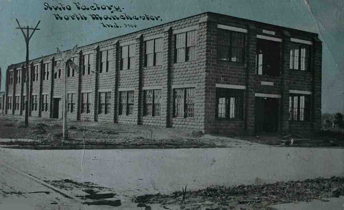
handle factory for the Baldwin Tool Works of Parkersburg, West Virginia. During this restructuring the top floor was removed. Jack Lennon was in charge. But ere long all the available ash timber hereabout was used and the handle factory machinery was moved away. For a time Lennon continued , making golf clubs, but the supply of hickory, too, was limited and the business was soon abandoned. Again the building was refashioned and it became the site of Kenton Priser's Chrysler Products Agency. By 1976 Pudge Egolf was making a replica of the original DeWitt auto buggy there. Then after extensive renovating, the building became the home of Kirti Shah's Custom Magnetics, Inc. | ||
Page Two | ||
John, Jr. was probably the first to carry mail regularly between Lagro and Liberty Mills. He followed a trail out of Lagro past the Catholic cemetery and straight north to the plank road that John Comstock built from Liberty Mills to Huntington, a route long known as the Mail Trace Road. It is said John made the trip by foot and was a day going to Lagro and a day returning. One account says the county commissioners appointed John to view and establish a road between Lagro and Liberty Mills and that he reported on the Mail Trace route. At least, the road was cleared of brush in 1838 with the energy of the Simontons, the Abbotts, John Comstock and others and the Lagro people in their area. Not all the big trees were cleared until 1844. According to tradition the four Simonton men and James and George Abbott were the first to make a trip with a wagon and oxen from Liberty Mills to the Turkey Creek prairie country in Koscuisko county and to the Wolf Lake mill in Elkhart county, then the nearest place where flour was milled and seed wheat and other grain was available. It took them several days to make the trip. Part of the way had to have brush and logs cleared from the trail. The first death in the family was the daughter of Jacob and Leah Simonton born October 2, 1832 in Ohio who died July 4, 1839. There was no cemetery so a spot was selected on the southwest corner of her grandfather's farm. It was just north of where the east-west road should be and just east of the north-south road. A few years later a child of Joshua Simpson, who lived just south of the Simontons, died and was buried on the northwest corner of the Simpson farm just a rod or two south of Mary Simonton's grave. So a cemetery was started. There was no road then. There were more burials through the years and when the road was established it jogged north three or four rods, then east about fifteen or twenty rods and then south to the section line again. Simonton set aside a half acre of ground for cemetery purposes and also a site for a church. Simpson similarly donated a piece of his land and the width of the road added to the amount in the original cemetery site. Still later land to the south was donated or purchased. Simonton stipulated that the people of any denomination should have the use of the church for the purpose of holding funerals. This | ||
Page Four | ||
condition was accepted and a log building built that was used as a school house during the week and as a church on Sunday. In 1844 Elder Joseph Roberts organized a class of the Christian faith at the home of Isaac Robbins, who had entered the land north of the Simonton farm. The congregation wanted a meeting place. On April 10, 1847 the half acre for the cemetery and an acre for the church was deeded to the Wabash county Commissioners for the church and cemetery. A frame church was built in about 1858 and about fifty years later the more recent church was built. When the Pleasant Grove Cemetery association was formed in the 1930s, the cemetery was deeded to this association. It is still under their ownership. Many Simontons rest in the Cemetery. Leah Simonton, born October 29, 1812 and died October 2, 1851 just 29 years to the day after the birth of her daughter Mary, and they lie together. John, Sr. died August 30, 1852, at the age of almost 72. His wife, Elizabeth, died May 8, 1851 at the age of 57. Both are buried on the lot north of their granddaughter and daughter-in-law. Jacob later remarried and moved to Iowa where he became a circuit court judge and gained a state wide reputation for fairness and keen judgement. David and his family also moved to Iowa. Elizabeth and her husband moved to near Kalamazoo, John, Jr. led an active life. He at one time was township assessor. His outspoken opinion was the only thing that kept him from being one of the jurors that convicted John Hubband of the murder of the French family in that famous trial. The judge questioned Simonton as to whether he had any opinion about Hubbards' guilt. He replied that he had and when asked his opinion he said, "He ought to be stretched up by a rope and left there until the little ducks pick his toes to pieces." The judge may have had the same opinion but it disqualified John as a juror. John and Martha Simonton were the parents of eleven children. They were David, Sarah Ann, wife of Martin Huffman, Harriet Rittenhouse, Lavina, wife of William Keller, Jacob, Mary Jane, wife of John Cuppy, Mahala, wife of Ben Nordyke, John C. who died in Nebraska, Robert, Perry and Charles or Charley.. Both Charley and Perry were dwarfs and created considerable attention. Perry was born | ||
Page Five | ||
increase into the north part of town nearer the bridge and business was being taken from the downtown section, largely controlled by Mr. Comstock. Soon he became interested in converting what had been a ford and a ferry during high water, into another bridge. First a crude bridge was built. Then it was replaced by a covered bridge in the early seventies. This covered bridge was replaced by a river bridge and a race bridge - both build at the same time. The highway to the west which angled through Mr. Comstock's farm and past the family cemetery he created also may have influenced the location of the bridge. John Comstock in his day was easily the biggest and most influential business man and farmer iin Northern Wabash county. He was a member of the State Legislature and a probate judge and was progressive in many ways and as stubborn as an ox in others. When the canal was built through Lagro he maintained a warehouse at Lagro and attracted business men to Liberty Mills faster than to North Manchester. However, he could not stand competition, and because of his buying power, could undersell those who dared compete with him. Some of the early business men came to North Manchester. In fact, it was not uncommon in telling the history of an early North Manchester business man to mention that he first located in Liberty Mills. Mr. Comstock was active in getting a plank road built from Lagro to the north part of the county, no doubt thinking it would be routed to Liberty Mills. When he found it was to be routed to North Manchester, he sold his warehouse in Lagro and wiped the town off his business map. He then headed a company that built a plank road from Liberty Mills to Huntington and the route of this road still exists in places today. Robert Carson, who had married Sarah Comstock, a daughter, kept the toll gate at the east edge of Liberty Mills. The Comstock residence, called the toll house, later became the Wayne Rittenhouse residence. An early map of Liberty Mills, drawn shortly after the Detroit and Eel River railroad was built, shows an elevator, depot, switch tracks, saw mill, three stores and two shops, all located on Second street in the north part of town. At the corner of Second and North street was an | ||
Page Ten | ||
L-shaped hotel and there were two doctor's offices, Dr. Banks and Dr. Lent Lower. Earlier Dr. Peter Bender had practiced there, but later moved to Laketon. Dr. Lower moved to North Manchester and built what was later the office building of Dr. Worth M. Walrod, and the residence property to the north on the northeast corner of Second and Market. On Main street was the Post office in the west part of town, the R. Carson general store, a drug store, groceries and other retail establishments. A church had been built and also the school on the site of the later building. Some distance to the south was the grist mill and along the race and between the race and the river were the other businesses belonging to Mr. Comstock. In later years there were two factories operated by brothers. Ed Rittenhouse operated the grist mill and also manufacturered seed sowers. He powered the entire business by water power until in later years when he generated electricity with water, not only for his mill but also the light for the town. In the north part of the town near the railroad was a factory operated by Freeman Rittenhouse who manufactured shovels and other hardware. Later he moved this factory to Akron and it came into other ownership. James Abbott from whom the Abbott families in this locality traced their ancestry, was born in South Carolina, the son of a Revolutionary soldier. Abbott was a member of General Wayne's army when the Indian Confederacy was broken in the battle of Fallen Timbers in Northern Ohio and after the treaty of 1826 which opened Indiana land to settlement north of the Wabash river, he decided to try his fortune in the land he helped win from the Indians. The first school was taught in a log cabin by Miss Harriet Tullis and in 1841 a building was constructed that lasted until 1872. In that year a large two story building was built - a combination school and town hall. Part of the cost was paid by Liberty Mills people directly for the privilege of having a hall. This building endured until 1903 when it was dismantled and the building still standing was built on the foundations of the old. Why did not Liberty Mills with its early advantages over North Manchester, not become the largest town in the north part of Wabash | ||
Page Eleven | ||
Capt. William Wells in Ft. Wayne where he died in 1812. About two miles south of Columbia City route 9 crosses Eel River,, Just south of the river is an elevated piece of ground known in early days as "The Island." Then it was about 300 acres of land bounded on the north by the Eel and on the West, South and East by very swampy land . There the Indians could retreat and defend themselves from enemies. Sometimes their primary enemies were the Potawatomis and sometimes the whites. Below "The Island" Eel River becomes larger with the addition of the waters of Mud Creek and Blue River. For about sixty miles there were no major villages because of the conflict between the tribes but many boats were on the river and important trails followed the river. It was a land of abundance. Lots of nuts, berries, maple syrup for the making , and an abundance of wild animals and fish in the river. There were other villages of note: Chief Pierish on what is now the Manchester College sports field, one mile below Roann, at Stockfale a village called Niconza, or Squirrels village, a Potawatomi chief. Opposite the present town of Chili was a Miami village with Chief Captain Flowers One of the most important villages in all of Indiana was about seven miles from the mouth of the Eel not far from the town of Adamsboro where for a century or more the Miami town of Kenapecomaqua was a threat to all white settlement. The early settlers came to know it as one of the most dangerous which sent out bands of raiders to descend on frontier settlers. It was captured after a battle led by General Wilkinson in 1791 and the head of the village, known as the Soldier signed the Treaty of Greenville in 1795. This village later became known as Old Town on the Eel. Below Old Town, near Logansport, the adventuresome Eel flows into the Wabash, to continue its journey on to the sea. | ||
Page Fifteen | ||