Source: Wikipedia, December 2014
Source: NMHS Newsletter, May 1998
The Mighty Teays
by Ferne Baldwin
John Muir said in "Sierra Fragments" (1872) "Glaciers make the deepest mark of
any eroding agent, and write their histories in inerasable lines." During the
Pleistocene Epoch glacial ice moved into Indiana at least three times and
perhaps many times. At the maximum, five-sixths of the state was glaciated. In
these ancient times before the Ohio River or the Great Lakes came into being,
the great Teays River system drained much of what is now the east- central
United States. The Teays entered what is now Indiana in southern Adams County
and flowed across northern Jay county into Blackford County and then through
Grant and Wabash counties.
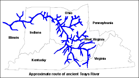
The origins of this system were in western North Carolina and it flowed
northward across Virginia and West Virginia, turned westward to Scioto County,
Ohio, then generally northward across Ohio. Some scholars argue that it
continued to flow into what is now Lake Erie but the majority opinion is that it
turned westward into Indiana, continued into Illinois, turning sharply southward
in west Illinois to what was then the Gulf of Mexico near the southern tip of
Illinois.
The river varied from one to two miles wide and up to 500 feet deep. What is
called the "deep stage" was more than 300 feet below the upland in Wabash
County. About two million years ago as the glaciers of the Pleistocene Ice Age
came across Indiana they filled the Teays with the great load of accumulated
sand, gravel and rocks pushed before them. Much of the character of the
landscape of Northern Indiana today arises from this glacial activity.
About 13000 years ago the development of the Great Lakes was underway but it was
not until about 11,000 years ago that these lakes had reached something near
their current contours. Some other lakes developed in Ohio and Indiana if there
was not easy exit for the meltwater as the glaciers melted. The largest of
these, Lake Tight, named in honor of the work of W.G. Tight, is estimated to
have covered an area of nearly 7,000 sq. miles in southern Ohio and part of West
Virginia and Kentucky. From an examination of the sediments accumulated
scientists have concluded that it existed for at least 6,500 years.
North of the Wabash River many well known lakes were formed by gradual meltdown
of ice blocks. Bass Lake is an example of what is called a pit lake. Others are
called kettle lakes and include Lake Wawasee and Lake James. The former Beaver
Lake (now completely dry) occupied 28,500 acres in 1834. Human activities
reduced it to 10,000 acres by 1917. Other glacial lakes have disappeared due to
agricultural activity and residential development.
The buried Teays Valley enters the southeastern corner of Wabash county and
about 18 miles of its course lies within the county. The "deep stage' is narrow,
gorge-like within the broad, old age valley. If the bedrock formations were
exposed, the steep walls along the "deep stage" would provide explanations of
the sudden drops in the bedrock surface reported by well drillers.
The buried Teays valley is not a buried flowing river or what we might call an
underground river. The valleys of preglacial and interglacial sluiceways
generally contain thick extensive beds of gravel and sand. These deposits which
lie buried under younger drift are excellent ground water reservoirs. Those that
are found at the base of the drift in the "deep stage" Teays valley and its
tributaries are of crucial importance to Wabash County and northern Indiana. For
North Manchester, the buried Eel Valley is the most important tributary. Gravel
and sand are abundant throughout the Packerton moraine area, and few wells have
to be dug to bedrock for water.
The first wells for the city of Wabash were several flowing wells south or
Treaty Creek. More recent must be pumped. They tap an aquifer in coarse gravel
within a comparatively small, southward trending tributary of the Teays. The
city of Peru in Miami county obtains its water supply from wells completed in
gravel in the "deep stage" of the Teays valley. There are no doubt many other
cities depending on Teays valley deposits for a secure city water supply.
Present day surface evidence of the Teays system is limited. In southern Ohio,
which was not covered by glaciers, there are great deposits of what is called
Minford clay, that accumulated in lakes created when the Teays was dammed by an
early glacier. This clay deposit varies from 80 - 260 feet thick in parts of
Madison county. Mapping of the bedrock surface beneath the glacial drive is now
being done. The maps depict the configuration of the bedrock surface as if all
overlying unconsolidated sediment had been removed and will show the course of
preglacial valleys.
Where the glacial sluiceway cross buried valleys, they widen abruptly. The most
obvious example for us occurs at the "prairie" west of Wabash, where the Wabash
Valley crosses the buried Teays Valley. Above the "prairie" the Wabash River
flows in a rock-walled valley from half a mile to l mile in width. At the point
where the present Wabash Valley crosses the buried Teays Valley, it abruptly
becomes a broad open valley from two and a half to three miles wide. Bedrock is
exposed along the north side of the valley.
Modern satellite images show the old Teays as light-colored, broad valleys in
areas of Ohio that were never covered by glaciers. The limits of the Wisconsinan
glacier in Indiana and Ohio are readily visible. Mapping the Teays in areas
which experienced deep glacier deposits is more difficult but it will be
completed and we will have a much better understanding of this great river
system.