NEWSLETTER OF THE
NORTH MANCHESTER HISTORICAL SOCIETY, INC.
VOLUME IX, NUMBER 3 (August 1992)
Then and Now, 1834 to
1992
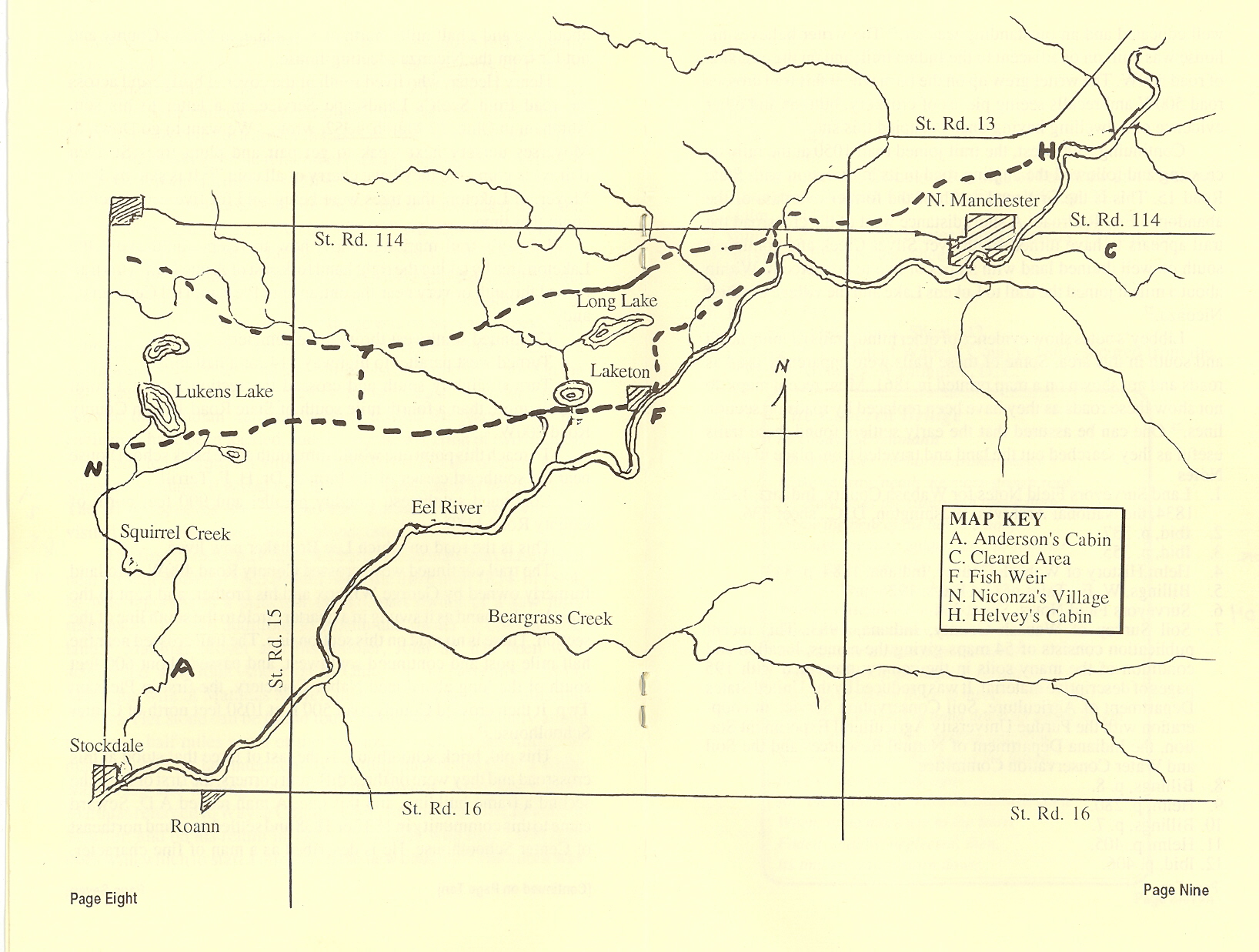
North Manchester, Indiana to Stockdale, near Roann
By Lester H. Binnie
John Hendricks, Deputy Surveyor, working on contract
for the Federal government, with his small crew, two axemen, two chain
carriers and a hunter with a pack horse, set a post in the middle of East
Street on the sixth day of March, 1834. The exact spot is in line with the
south property line of the Heeter Performance Center. If you stood there
today, you would see a small hole at your feet. Below this hole, perhaps six
or eight inches deep, is an iron peg that replaced the post. This peg was
uncovered, perhaps this year, likely establish the property line of someone
living in the area. On that same day in 1834, John and his crew had
established the section line from the north bank of Eel River to this point.
There were no good witness trees nearby to mark the location of the post,
but two white oak trees were marked by the axemen at some distance. One was
15 inches in diameter standing 21 feet southeast of the post and the other
56 feet northwest. John described the land along this section line as “Land
Rolling and second rate, oak timber inclined to Barrens, some small
Prairies.”[1]
Barrens were open and park like and grass provided the ground cover. The
grass was mostly Indian grass and tall bluestem, often as high as six or
eight feet, and the chief forage for the bison. Believe it or not, tall
bluestem can be found growing in North Manchester after 158 years. Look for
it in late summer on the abandoned railway right-of-way on Wayne Street and
south of the Manchester Clinic.
On that same day in 1834, John Hendricks surveyed the
section line extending east from the post. At a distance of 1650 feet in a
wet prairie his notes state, “About 10 chains (660 feet) South a cabin built
by H.”[2]
On the survey of the Meanders of Eel River, conducted on 27 August, 1834,
the cabin built by H is identified as Helvey’s House.[3]
Richard Helvey (Helvie), a trader living in Lagro in
1832, moved to this location at the east end of Orchard Street during the
winter of 1833-34.[4]
There was an Indian village at this location. One reason for the village was
apparently the large free-flowing spring near the river which has since
disappeared because of a drainage project.
[5] One may speculate that Hendricks and
his crew took time off to visit Helvey, fill their canteens with fresh
spring water and, perhaps, sample his fire water. Hendricks likely paced off
the distance (10 chains) while going or returning to the section line.
Helvey may also have considered the prospect that corn would be readily
available to supply his small still.
On 28 May, 1828, David Hillis, Deputy Surveyor, stood
on State Highway 114 E at the corner where the Chester Township Fire
Department is now located. He reported, “At this corner there appears to
have been an ancient Indian village of considerable extent. Timber remaining
is mostly oak. There is perhaps 60 or 70 acres entirely clear, seems to have
been cultivated, a small distance SW of this corner.”[6]
On a modern soil survey map the soils where this field was found are nearly
level. They are named Fox loam, Kosciusko sandy loam and Ormas sandy loam.
All are productive, somewhat low in water holding capacity; but, now they
are used extensively for the production of corn and soy beans.[7]
This field was only about one and a half miles southeast of Helvey’s cabin.
To reach it on foot and avoid the flood plain and swampy areas, the trail
would most likely have extended south and a little west to a point near the
covered bridge where the river could be crossed at a ford. From there the
field was about one mile east and a little north.
Helvey’s cabin is said to have been a grand one for its
day, being a double cabin, having two rooms. It was in use for many years by
the Harvey Cook family.[8]
Other records indicate that there were no other settlers closer than
Anderson north of present Stockdale. In the fall of 1835, the families of
Col. Helvey, James Abbott and Peter and John Ogan assembled in the cabin of
Peter Ogan to participate in the religious exercises of the Christian Church
led by the Elder Briant Fannin.[9]
Helvey did not remain a trader for very long. In 1840-41 he moved to town
where he was host at the American Hotel, a two-story frame building at the
corner of Walnut and Main Street. Helvey is said to have moved to Logansport
for a short time. Returning to a farm southwest of town, he died there in
1850 of lung fever. He, his wife and two children were buried in the extreme
north end of Halderman Cemetery.[10]
Of the travel routes that led to Helvey’s cabin, the
Eel River was perhaps the most important, but overland trails in the area
had been in use by the Indians for many generations. These trails served as
roads for the early pioneers when the land was opened for settlement.
Cornelius Halderman, then age 21 and traveling on horseback, went through
the woods from Helvey’s cabin to the cabin of Mr. Anderson in April, 1835.
Anderson had established a residence about one an a half miles north of
present Stockdale and about two miles southeast of the village of Chief
Niconza (Squirrel in English). The village was in present Miami County.[11]
Whether or not Cornelius was related to Allen Halderman who died in North
Manchester on 2 March, 1845 has not been established.
In July, 1835, a party of seven families including
those of Jesse Myers (Moyers), Jacob Gill and Matthias Lukens, a lad of 18
years, followed an Indian trail from North Manchester to the Squirrel
Village and to Anderson’s cabin about a mile above it and on Squirrel Creek.[12]
Matthias Lukens has said that the party arrived in the North Manchester area
from Lagro and there were 60 Miami and Pottowatomie Indians camped across
the river from the present town.[13]
Now the question arises, where was the trail leading to Anderson’s cabin?
This problem is solved through the records of another surveyor.
Sylvester Libbey, Deputy Surveyor, on 26 February,
1834, began establishing section lines at present Stockdale, north of the
River. His contract covered land extending north nine or more miles and east
as far as present State Road 13 (Meridian Road). He was expected to follow
the standards as required by the Federal Government which in addition to
establishing the section corners required him to do the following:[14]
·
Find and mark the halfway points between
corners.
·
Record the kind and size of trees on the
section line.
·
Record the kind and size of the witness trees
at corners and halfway points.
·
Record the size and quality and direction of
streams crossing section lines.
·
Record the lakes on section lines or in view.
·
Record the distances where marshes, swamps
and prairies were entered and left on section lines.
·
Make an appraisal of the quality of timber
within the section or along the line.
·
Give his opinion of the quality of the land
for agricultural purposes, i.e. first, second or third class.
At Stockdale, near Roann, Libbey became involved in
details. Quoting from his notes at random: “ascend gently and enter an open
oak woods, ascent a steep bank 10 feet high, descend a steep bank 20 feet
high, a spring a few feet south of the line, an Indian trail NNE. The
Indians have 10 to 12 acres enclosed and have raised corn, potatoes and
vines. Several houses on the river bank, mostly deserted at this time.” He
soon gave up most of these interesting details probably because they used up
valuable time in completing the survey. However, one item he continued to
report was the location and direction of most Indian trails where they
crossed the section lines. Now it is possible to locate these points with
accuracy. All that is required is the conversion of Libbey’s 66 ft. chains
and 7.9 inch links into feet and measure the distance from the section
corner. Furthermore, by recording this information on the, four inches to
the mile, soil survey maps, the trails can be related to the soil. Having
combined these two surveys, it is shown that the trails were on nearly
level, high, well drained soils, usually at a distance of a half mile or
more from the river. These soils were covered with timber; poorly drained
soil, flood plains and swamps were avoided.
Hendricks did not record an Indian trail from Helvey’s
cabin to present Indiana Highway 13, but the soil survey map provides
information on the location of nearly level, well drained soils between
those two points and for an additional mile. Using this material, the writer
believes the trail to Anderson’s house was as follows:
West on or near Orchard Street to East Street.
Southwest through the college campus.
South of the Manchester Clinic and west on or near College Avenue to
Market Street.
Southwest through the High School campus and across the northwest
part of Oak Lawn Cemetery to Strauss Provimi Road and continuing southwest
to a short distance north of the intersection of Indiana highway 114 and 13.
West, roughly parallel to highway 114, for a distance
of about a half mile, then northwest and over Clear Creek and to high
ground, then southwest on the west side of the little known Old Cripe
Cemetery and to present road 114 at a distance of 924 feet east of Acme
Hall. (The one-room schoolhouse at West Manchester Church.)
From this point the trail markings of Libbey come into
use in identifying the trail to Anderson’s cabin. A short distance west of
this point, he shows that the trail divided, one leading south, the other
continuing southwest.[15]
We will trace the one leading south first.
On the high ground, east [sic; correction: west] of Clear Creek, the trail
extended south past the Grandstaff Rendering Plant and parallel to the Ogden
Road, but usually about a fourth of a mile distant. After crossing Otter
Creek it continued southwest on the high bank and the west edge of Laketon
Bog. On the nearby section line, at a distance of 2635 feet north of the
river, Libbey recorded “two unfinished mounds a short distance west of the
section line.” The distances in links and direction were also given.[16]
These mounds were apparently within the road right-of-way. The trail
continued south through the former Laketon Nursery and joined the Ogden Road
a short distance south of the Laketon School property.
At the south end of Main Street, the trail was on the
high bank and overlooked the Indian fish weir just below. This structure,
constructed of large glacial boulders, can be seen today. First cross the
bridge and turn right into the Public Access Area, then follow the riverbank
down stream about 200 feet. The high bank was likely the site of an Indian
village at various times. Howard Rager lived at this spot during the period
from about 1920 to 1950, and it was there that he manufactured reinforced
concrete corner, end and line posts. Now between State Highways 114 at North
Manchester on 13 and south to 16, there are more than 50 corner and end
posts and many line posts reflecting his style. Look especially at the
fences along the property of Charles Signs, south to the overhead bridge.
While leveling the ground for his operations, Rager uncovered a complete
Indian skeleton. Mary Ohmart believes it was given to a doctor in Laketon.
The writer believes it may have been the skeleton he remembers seeing
hanging in the office of Dr. John Wilson during the 1920s.
From the south end of Main Street, the trail extended
west and very near the south edge of Round Lake,[17]
and past the soon-to-be-built corn cracker mill of James Cox on Silver
Creek.[18]
It is said to have been the first mill in Pleasant Township. After passing
the south end of Lukens Lake on high ground, the trail continued southwest
to the village of Chief Niconza. The village was on Squirrel Creek south of
present Niconza Church in Miami County. It appears that Anderson’s cabin was
about a mile south and a mile east on Squirrel Creek. On the east side of
Section 26, Twp. 29 N, Range 5 East, surveyor Libbey showed three Indian
trails converging toward the place where the cabin may have been located.
Judging by the direction of two of these trails, one led to Squirrel village
on Eel River and the other to Chief Niconza’s village. It is said that
Anderson built a mill at this location. The writer believes this was the
trail followed by those who had visited Helvey in present North Manchester.
The first of these travelers, Richard [sic; correction:
Cornelius] Halderman,
purchased land near present Roann in 1835 but did not settle there until
1854. In 1884, he was reported as a principal citizen, part owner of a saw
mill, responsible for two additions to Roann and owner of considerable land.[19]
Matthias Moyer and his brother, John Sr., had been well acquainted with John
Anderson in Ohio. On 30 November 1835, Mary, the wife of Matthias Moyer,
died, age 31 years, 5 months and 22 days. Her stone can be found today in
the Moyer Cemetery about two and a half miles south of the Niconza church.[20]
John Anderson made a coffin for her internment by splitting puncheons from a
white walnut log and hewing them down into boards. After Mary died, Matthias
returned to Wayne County, Ohio, for another wife, Elizabeth Stauffer; and on
his return in 1838, he brought with him 7,000 fruit trees with which to
start a nursery in the new country.[21]
Henry Heeter, who lived south of the covered bridge and across the road from
Scott’s Landscape Service, in a letter to his son, Abraham in Ohio, 17 March
1852, wrote, “We want to go Down to Moyerses nursery next weak to get pair
and plum trees. Steaven (Ulrey) is going too they have cherry of all coin.”[22]
It is said by John Moyer, of Laketon, that trees were being sold for five
cents each at about that time.
Libbey’s trail markings show how travelers could avoid
the Laketon area by taking the right hand fork east of Acme Hall. This trail
passed through or very near the entrance to Pleasant Hill Cemetery[23]
and:
Continued southwest through the cemetery,
Turned west parallel to highway 114 for a half mile,
Turned slightly south and crossed the section line at a point
slightly more than a fourth mile south of State Road 114 on County Road
200W.[24]
To reach this point one would turn south at the brick school house
near the southeast corner of the farm of Dr. H.F. Terrill.
Continued southwest, roughly parallel and 900 feet north of County
Road 1150.
This is the road on which Lee Brubaker now lives.
The trail continued west, crossed County Road 400W onto
land formerly owned by George Willcox and his brother, and kept to the most
level ground as it swung in a quarter circle to the south line of the
section. There is no road on this section line. The trail crossed near the
half mile post and continued southwest, and passed about 600 feet south of
the long abandoned Nabor Cemetery, the first in Pleasant Twp. It then
crossed County road 500 E at 1050 feet north of Center Schoolhouse.[25]
This old, brick schoolhouse is the last of three that
stood at this crossroad and they were on three different corners, the first
of logs, the second a frame building, and this one. A man named A.D. Seward
came to this community in 1837 or 1838 and settled near and northeast of
Center Schoolhouse. He is described as a man of fine character., well
educated and an outstanding teacher.[26]
The writer believes his house was built on or adjacent to the Indian trail,
and on the east side of road 500W. The writer grew up on the farm where this
trail crosses road 500W and recalls seeing pieces of crockery, buttons and
other evidence of a dwelling having once occupied this site.
Continuing southwest, the trail joined to its
intersection with State Road 15. This is the first road south of the former
overpass of the abandoned Erie Railroad. A short distance west of the
crossroad the trail appears to have turned south over Silver Creek and
continued south on well drained land with slopes of two to six percent.
Within about a mile it joined the trail to Lukens Lake and the village of
Chief Niconza.[27]
Libbey’s notes show evidence of other minor trails
running north and south in this area. Some of these trails were apparently
used as roads and are shown on a map printed in 1861. More recent maps do
not show these roads as they have been replaced by roads on section lines.[28]
One can be assured that the early settlers found these trails useful as they
searched out the land and traveled from place to place.
[1] Land
Surveyors Field Notes for Wabash County, Indiana, 1828-1834, the
National Archives, Washington, D.C., sheet 336.
[4] Helm, History of Wabash County,
Indiana, 1884, p. 343.
[5] Billings, W.E., Tales of Old
Days, 1926, p. 7.
[6] Surveyors Field Notes, Sheet 334.
[7] Soil Survey of Wabash County,
Indiana, 1983. This recent publication consists of 54 maps giving the
names, location and condition of the many soils in the county; presented
with 195 pages of descriptive material. It was produced by the United
States Department of Agriculture, Soil Conservation Service in
cooperation with the Purdue University Agricultural Experiment Station,
the Indiana Department of Natural Resources and the Soil and Water
Conservation Committee.
[14] Surveyors Field Notes, Sheet 17.
[20] Binnie, Lester H., Cemetery
Records of Paw Paw and Pleasant Townships, Wabash County, Indiana, 1982,
p. 35.
[21] Surveyors Field Notes, Sheet
427.
[23] Surveyors Field Notes, Sheet
427.
[27] Surveyors Field Notes, Sheet
443.
[28] Skinner, R.J., Map of Wabash
County, 1861, secured from the National Archives, Washington, D.C.
The Covered Bridge by Gladys Scheumann
No more does the horse-drawn buggy
Make its way ‘neath the moss-grown roof.
No more does the sturdy old plank floor
Know the beat of the horse’s hoof.
Through the long golden days of summer
while the stream idles by in the sun,
Does it dream of the days of yesteryear,
When its usefulness just begun,
It gave many a weary rider
Cool shelter awhile from the heat?
And I wonder, if, perhaps, it recalls
How lovers came there to meet;
They’d stroll hand in hand down its shady length
With steps that were carefree and slow,
Spinning rainbow dreams of the future,
In those days so long ago---
Ah! The old bridge fears the days
will come
When, of no more use to the town,
Faded, shabby, neglected, then
Its timbers will be torn down.
Opera House Fire
Letter
to the News-Journal from Leola Hockett, Wabash, March 31, 1944
[From the North Manchester Historical Society Museum]
I saw the statement in your paper
after the recent fire that no one could recall the date of the fire that
destroyed the opera house.
In the Manchester Journal of October 15, 1885, is half a page about that fire
from which the following is taken:
“At one o’clock Sunday night fire was discovered in the Hidy Brothers
Restaurant. When discovered, it had
spread to Johnson’s barber shop on the west and to the Thomas Clothing Store on
the east. These buildings were all
old frame structures, and the fire spread with lightning rapidity.
“At this time the flames could have been easily extinguished, but at this
juncture it was found that the fire engine was disabled and could not be used,
although it had been in the shop for repairs since the Tuesday preceding.
An effort was made to fix it for service which was finally successful,
although the machinist had declared that it was perfectly useless.
“There had been
several damaged flues taken out of the engine, and the one ordered to replace
them had not yet arrived. Finally
some men were induced to go to work on it, when it was seen to what
uncontrollable magnitude the fire was spreading.
In a short time the disabled flues were plugged up and a fire built in
the box. The engine worked and was
taken to the cistern at the corner of Main and Market Street, and about half
past two was throwing water.
“In the meantime the
flames had devoured several buildings placing the entire south side of Main
Street in great danger of being destroyed.
The three buildings mentioned were entirely comsumed.
Jenning’s grocery was a mass of flames; Hamilton’s saloon and Krisher’s
meat market were burning rapidly; and the flames had caught in the opera house,
the roof of which was burning.
“…Although the fire
company had arrived on the ground soon after the first alarm and worked with
might and main, assisted by the crowd, they seemed powerless to check the
spreading conflagration. Bucket lines were formed to the river and wells nearby,
and all attention was turned to saving the buildings that had not yet been
attacked.
“The engine was now
playing on the opera house and succeeded in arresting the fire before it caught
in Johnson’s livery stable in the rear, but not before the entire upper story
and nearly all of the livery barn was destroyed.
The fire was under control when the Wabash fire department, which had
been sent for in the beginning, arrived.
The Wabash fire department received the word shortly after one o’clock
but did not get started from that city until 2:25, owing to a combination of
circumstances… They made the trip in exactly 25 minutes, including two stops for
water and one crossing.,. Although
too late to be of much advantage, yet had not our engine been fitted for
service, it would have been of incalculable service to the town.
“The loss is estimated
at from $20,000 to $30,000. Very
little of this loss was covered by insurance.
“Repairs for the
engine arrived on Monday.”
“The new fire bell
which was placed last week on the tower built for it did good service in
arousing the people from their slumbers.”
“The loss of the opera
house left the town without a public hall of any kind.
The following from a Wabash newspaper shows the rapidity
with which things were accomplished in the so-called “good old days.”
“On Sunday night the city night watchman was called to the
telephone exchange to receive the startling information that the business
portion of North Manchester was on fire, and the Wabash fire department was
called to the rescue.
“Hastily mounting one of the horses in the city hall, he
galloped to the residence of mayor Stephenson to get an order for sending out
the firemen, while others aroused Mr. Lamport, Superintendent of the C.W. & M.
Railway who promptly ordered an engine out to take the train to Manchester.
At one o’clock the general alarm was sounded, and, long before the
locomotive could be steamed up, the firemen had made up the train consisting of
a flat car for the engine and hose reel, a box car for the horses, and a coach
for the firemen. The train left the
city at 2:25 and made the run in exactly 23 minutes after leaving the yards, and
in a very few minutes after the engine was unloaded, was run downtown, and set
on the river dock, but by that time the fire had nearly burned out.
The train returned about four o’clock.”
Manchester Owns Hidden Treasure----Koinoinia
By Elizabeth L. Hendrix
From College Avenue to County Road 650 East, from one man’s
dream to a retreat and environmental center---that’s Koinonia.
Nearly 30 years ago a small group met for prayer and study.
One of the group, Hubert Newcomer, suggested that it would be wonderful
to have a family retreat center and that a piece of land suitable for such a
facility was for sale because of tax indebtedness.
The idea caught fire, and 12 families who facetiously
called themselves “disciples” scraped together $250 each to secure the 80-acre
farm which went on the auction block for $9,200.
The next few years were spent sprucing up the area and
caring for the property. When the
old Oaks, a Quonset hut on College Avenue, was scheduled for razing to provide a
parking lot, the disciples bought the building and built a foundation at the
retreat center on which to place it.
Close scrutiny revealed, however, that the Oaks had paid its dues and was
not in condition to continue as a family lodge.
Undaunted, the disciples stretched their finances still further and
erected a lodge on the foundations built for the Oaks, not as expansive as it is
now, but adequate for families’ weekend retreats.
There are rumors that mothers of teenagers held slumber parties there!
As other families became interested, T. Wayne Reiman,
professor emeritus of Manchester College, suggested that the retreat be called
“Koinonia,” which means Christian fellowship or body of believers.
The Japanese translation is “Garden of Goodwill.”
As time passed the disciples grew older, as disciples do,
and some moved away. It became
increasingly harder for the few able-bodied friends to manage the upkeep and
improvement of the facility.
In the original charter three options were established for
the disposal of the property, should htat be a necessity.
One was to offer it to the college, which they did, and Manchester
College acquired Koinonia in 1975.
Dr. William Eberly, chairman of the Natural Science
division of the college, said he had been hoping for such a facility for years
to give practical experience to biology and environmental students, especially
students training to be teachers in those areas.
Koinonia Environment and Retreat Center is an 80-acre
facility with a five-acre lake and hardwood and pine forests.
The College has improved the lodge facilities, has planted a ten-acre
arboretum, and is in the process of establishing a prairie area.
In 1989 Manchester College created the position of
Environmental Education Coordinator.
Barbara Ehrhardt, a Manchester College graduate, fills that position and
reports that the facility has been booked nearly every day.
The public schools of three area counties bring students to the nature
center to enjoy an outdoor educational experience geared to their specific
curricular needs. Ehrhardt’s hopes
are “to develop the potential of Koinonia so that it reflects the goals of
Manchester College and to develop quality environmental education for Manchester
students and the children of the community.”
She is excited about the grandparents’ program which she is
initiating. She states that the
expanding program is limited only by finances.
In her vision of the future is remodeling the lower area of the lodge,
creating additional educational programs, and developing ski trails.
Pumpkin Pie
Boil the pieces of pumpkin until tender, mash and remove as much liquid as
possible. Rub through a sieve and
add a good sized chunk of butter.
For each quarter of pumpkin add two quarts of milk and six eggs, the yolks and
whites beaten separately. Sugar to
taste. One teaspoon salt, a
tablespoon of ground cinnamon, one grated nutmeg, one teaspoon ginger.
Bake in pie crusts in a hot oven until well set and golden brown.
This should make a half dozen moderate size pies.