OGAN’S MILLS – 1837
SOURCE - WABASH COUNTY PLAT BOOK 1
MANCHESTER’S ORIGINS
by John Knarr
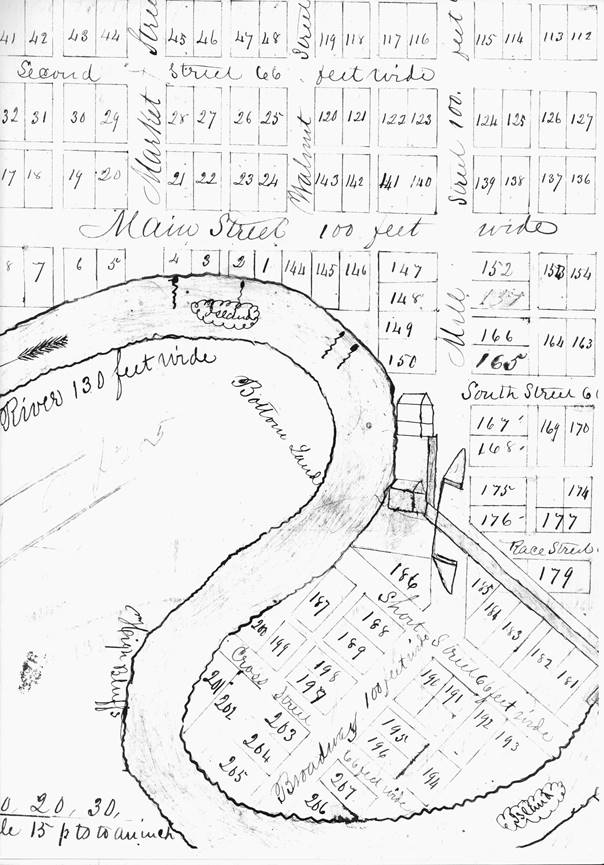
The earliest drawing that we can
find of the plat of Manchester is the one filed by Peter Ogan and surveyor J.J.
Tomlinson on January 4, 1837, more than 180 years ago.
A portion of that plat is shown on the previous page and can be today
found in the Wabash County Recorder’s Office. Interestingly, there are
variations in the pictorial representations of the Original Plat in at least
four different plat books at the county court house in Wabash.
In the Wabash County Plat Book 1, two mills are depicted. The mill race
and mill dam are clearly shown, the dam being adjacent to Lot No. 181. The
“State Road” between LaGro and Goshen crossed just below the dam. The Ogan mill
dam was located just below where the covered bridge was built. The old mill race
ran at an angle paralleling the angling Mill Street which connected to the
covered bridge. Before any bridge was constructed over the river, the so-called
“State Road” consisted of fording the river at the end of what was then called
Short Street. Since the mill race
could not practically be forded, a bridge was constructed to span the rushing
waters of the mill race. The very first drawing of Manchester’s Original Plat
has a pictorial representation of that bridge. The bridge across the mill race
at South Mill Street was the very first bridge constructed in our town. That
bridge spanned the mill race; bridging the Eel River took place much later.
Southwest of Laketon, one can still view (from Celia Shankster’s
property) another old mill race bridge where the old Laketon mill once stood.
Joe Vogel recalls that his ancestors once forded the Eel River to get to the
Laketon mill. But to cross over the deep mill race, a bridge must be used.
I also recall in years past crossing the mill race bridge at Liberty
Mills. In two plat books at the Wabash County courthouse (Original Plat Book 2 &
Plat Book No. 2), Manchester’s mill race bridge was not pictorially represented.
Also, in the Original Plat Book 2 the mill buildings were depicted, while
in the Plat Book No. 2 there were no pictorial representations of Peter Ogan’s
mills. The Wabash County Deed
Record Book A (p. 206) clearly showed the Mill Dam, State Road, Mill Race,
Race Bridge and two Ogan mills on South Mill Street. The northernmost mill was a
Grist Mill, and just to the south of the Ogan grist mill, there was depicted a
Saw Mill. The mill race bridge fronted the saw mill.
It is apparent that some details and especially pictorial representations were
lost in the process of redrawing the plats and transferring them to other books.
Peter Ogan built his log house on Lot No. 1 on Main Street on the northern river
bank. On the earliest plat map there were four springs represented by squiggly
lines in the river. I have found in doing research that the locations of such
springs either disappeared or inexplicably were relocated when the plat maps
were later reproduced. Importantly, Peter Ogan had good reasons to locate his
mills and his house where he did.
The following text accompanied the earliest drawing of Manchester’s Original
Plat:
Manchester is Situate in Wabash County at the Great Bend of Eel River on the La
Gro & Goshen State Road. Explanations – Lots are 4 ¾ perches wide by 9 ½ long
except the fractional ones. The marks along the Bluffs of the river made thus
(squiggle) indicate Springs Running into River. Lot No (1) begins at the end of
a line drawn south twenty eight perches and 23 links, then East (20) perches
from the quarter post on the North side of Sect 5 in Town No. 29 North of Range
No (7) East of the principle meridian. The streets north of Mill Race Run North
& South or East & West, those South of it form an angle of 46° with those north.
January 4th 1837
J.J. Tomlinson Surveyor of Fulton Co.
Editor’s Note: Peter Ogan’s younger
brother was also a miller. John Ogan’s mill was located south of town on the
creek flowing into the Eel River.
That creek was called “Swamp Creek” in the Surveyor’s Field Notes. John
Hendricks, the deputized surveyor for the federal government, measured the mouth
of “Swamp Creek” to be 35 links wide [April 27, 1834]. This stream became known
as Ogan’s Creek, and more recently named Pony Creek.
Editor’s Note: Both Ogan brothers signed as witnesses to a deed transaction that
took place on July 21, 1836 between Moses Summers and Solomon Charlesworth of
Henry County IN. Summers paid $150.00 for 80 acres of land “west half of the
north west quarter of Section No. eight, Township No. Twenty-nine North of Range
No. Seven East.” [Wabash County
Deed Record A, pp. 70-71] Section Eight was adjacent and just south of
Section Five. Ogan’s mills and Lot No. 1 were located in Section Five.
Editor’s Note: On December 22, 1843 Peter Ogan and his wife Nancy Ann (other
deeds have Mary Ann as Peter’s wife) sold to John W. Townsend and Jane his wife
Lots #1 and #2 for $100. On July 28, 1853, the Townsends sold the West half of
Lot #1 to William & Elizabeth Thorn for $300.
Editor’s Note: UNITS OF LINEAR MEASURE
1 Mile equals 5280 feet
1 Mile equals 80 chains
1 Chain equals 100 links
1 Link equals 7.92 inches
1 Rod, Pole or Perch equals 16.5 feet
Editor’s Note: UNITS OF AREA
1 Acre equals 10 sq. chains
1 Acre equals 43560 sq. feet
1 Sq. Mile equals 640 acres
A theoretical Township is six miles square, containing thirty-six sections, one
mile square, of 640 acres each. Area of a theoretical township is 23040 acres.
Editor’s Note: On May 12, 1834, while surveying the line between Sections 19 and
31 in Township 30, Range 7E, John Hendricks, the land surveyor, came across
early evidence outside of Manchester of a “state road” being marked: “A Trace
running SE & NW which is perhaps the track of a State Road we understand to be
laid out.” Remnants of this road can be tracked in the 1875 Wabash County
Atlas.
CANOES, BOTTLES AND THE OLD MILL RACE
During the recent excavations at the new canoe launch located at South Mill
Street, numerous old glass bottles have been uncovered.
Some have expressed surprise over such a discovery; others have assumed
that this site was formerly a town dump. Knowing our local history can help
appreciate such findings.
The old mill race cut across the peninsula along South Mill Streets. Some of the
ground excavated from the race was likely used in the original construction of
the Ogan dam. Laws at that time
pertaining to roads stipulated that a bridge over the race had to be built
before water was let into the channel. It was the duty of mill owners to build
and maintain a bridge over a mill race that crossed a public roadway. This
“common law duty” was affirmed by state statutes. [Chapter IV “County Road Law”
in Laws Relating to Highways and Bridges, Fort Wayne Printing Co., 1920].
The net effect of building the mill race in this way created an “island” between
the river and the race. This property was familiarly known as “The Island”.
When the milling activities at the Ogan mills waned
considerably as a result of stiff
competition from the Harter flour mill down river and as a result of the
eventual decline in the relative importance of waterpower, the mill race became
a large wet channel in the ground impeding movement and land ownership in the
immediate area.
In 1891 R.J. Parrett, property owner on the “island”, decided to fill in the
race. [North Manchester Journal, May 21, 1891] At this time the Burdge
building was being erected at the northwest corner of Main and Walnut Streets.
The year “1891” can be seen impressed on this building (AT&T store). A large
amount of dirt was excavated from this building site when a basement was created
in 1891, and this dirt became fill for the mill race. Our early merchants had a
habit of disposing of unwanted glass bottles and other debris with subterranean
burials under buildings and sidewalks. So it is conceivable that the recently
discovered glass bottles that have surfaced at the canoe launch site had
formerly migrated from such downtown construction sites.
Editor’s Note: The site of the covered bridge built in 1872 was located just
above or up river from the old dam and mill race so any impediment to travel
created by the mill race was necessarily bypassed and there was consequently no
legal obligation to maintain a mill race bridge.
Editor’s Note: Rev. R.J. Parrett held evangelistic tent meetings (U.B.) on the
island. [NM Journal, April 1, 1886] Various secular activities also took
place on the island such as horse races, circuses, and other events.
Editor’s Note: Harry L. Leffel in 1940 wrote that C.C. Winebrenner filled in the
mill race during the year 1920 [see NMHS Newsletter, Nov 1998]. Leffel
also claimed that there was no bridge across the mill race so that folks had to
wade through the shallowest part to get to the island. Oddly, Leffel failed to
explain why or how the community would make expensive investments in bridging
the Eel River, but refuse to bridge the race. The original bridge over the
channel apparently had fallen in some disrepair. Maps tend to show that the
channel had been filled by 1900.
STRATEGIC SIGNIFICANCE OF MILLSTONES
& THE AMERICAN REVOLUTIONARY WAR
Mills played an important role in our country’s economic activities and growing
independence. Philadelphia PA and Wilmington DE were early milling centers.
Quaker millers were central to the milling successes.
In 1823 Wilmington became known as “the Manchester of America”. The
reference here was to Manchester of England.
[United States Gazette, December 18, 1823] It should not stretch
credulity to suggest that the naming of our town “Manchester” in 1836-1837 too
was influenced by a miller’s mentality and his planned milling activities. [See
also “Why Manchester,” in NMHS Newsletter, February 2013]
During the Revolutionary War, in 1777, General Washington had instructed his
commanders to dismantle mills which were liable to fall into the British hands.
The mills played such a strategic role in the economy that on October 31, 1777,
Washington directed Gen. James Potter “to remove the running Stones from the
Mills in … Chester and Wilmington.”
Potter responded five day later after receiving his orders to remove the
millstones: “I’m a sorey to Inform your excelancey that the Officer I send to
the Brandywine Mills [Ed: Wilmington DE] has not obay’d my orders. Instead of
Taking the stone away he has taken the Spinnels, Rines and Ironnale heads….I am
Informed that Taking these Artecals answers the same end as Removeing the stons….”
Washington’s response was twofold: first, to court-martial the officer who
failed to remove the millstones; and second, to remove the millstones
immediately. Only when the British
evacuated Philadelphia in June 1778 were restrictions eased and the Wilmington
mills allowed again to commence normal operations. [Source: “Brandywine: An
Early Flour-Milling Center,” by Peter C. Welsh; pp. 677-686 in Annual Report
of the Board of Regents of the Smithsonian Institution 1959.]
JOHN COMSTOCK
ROAD COMMISSIONER IN 1842
On January 31, 1842, the General Assembly of the State of Indiana approved the
appointment of John Comstock of Liberty Mills as commissioner to locate a state
road north of North Manchester [see pp. 164-165 in General Laws of the State
of Indiana (1842)]:
SEC. 11. That John Comstock, of Wabash county, be, and he is hereby appointed to
view, mark and locate a state road, commencing at the south end of lot number
eighty-six, in the town of Manchester, Wabash County, Indiana, thence running a
north east direction to the dividing sections, thirty-two and thirty-three, in
township number thirty, range seven east, thence north on or near said line to
the north end of John Ulery’s land, thence on a direction a little west of
north, to the residence of M. Knoop, in Wabash county, thence in said direction
to intersect the state road from Lagro to Warsaw at the nearest suitable point
in Kosciusko county; and the said commissioners shall, on the sixth day of June
next, or within sixty days thereafter, proceed and locate said state road, and
make his report of the same according to law.
PETITION TO VACATE
STREETS AND ALLEYS ON THE ISLAND
Source: Wabash County Miscellaneous Record R, p. 315-317.
Proceedings before the Board of Trustees of the incorporated town of North
Manchester, Indiana, had before said Board at its regular meeting, at its office
in said town, and on the eighth day of October A.D. 1900, present to Charles
Kohser, William Wood and Hiram Whitlow, all the members of said Board of
Trustees, when the following proceedings were had:
Petition of Aaron A. Ulery to vacate streets and alleys in the Original
Plat of North Manchester.
Comes now said petitioner by his attorney, Isaac E. Gingerich, and
presents his petition heretofore filed herein on the 16th day
of August, 1900, praying said Board to vacate certain streets and alleys
specifically described and set out in said petition, and also files herein the
affidavit of said Gingerich and with notice attached that notice of this
proceeding had been posted in three public places in said town and in the
vicinity of the said streets and alleys on the 28th day
of August, 1900; and also files the affidavit of B.L. Martin & W.E. Billings
with copy of notice attached showing that such notice had been duly published in
The Weekly Rays of Light, a newspaper of general circulation printed and
published in said town on the 23rd &
30th days
of August and the 6th,
13th,
20th &
27th days
of September and the 4th day
of October in the year 1900, and no one appearing to said petition and no
opposition being made to the granting of such petition and the prayer thereof,
said petition on such notices is now submitted to said Board of Trustees for
hearing and trial, and said Board after hearing the evidence and the statement
of parties and argument of counsel does now find for the petitioner that all
matters and things alleged in his petition are true and that the public and no
person but the petitioner will be affected by the vacation of the streets and
alleys prayed for in such petition, and that the streets and alleys mentioned
and described in the petition ought to be vacated, and the Board further finds
that the public and all persons whomsoever have had due and sufficient notice of
the pendency of these proceedings by publication of notice and posting notices
as hereinbefore set out for a period of more than thirty days next before this
date and the trial and hearing of these proceedings.
It is therefore considered, adjudged, decreed and ordained by the said Board of
Trustees of the said town that the following streets and alleys in the Original
Plat of the said town of North Manchester, State of Indiana, be and the same are
hereby vacated, to wit: all of Cross Street; all of Short Street; all of
Broadway; all of the south end of Mill Street lying and being south of the
old Mill race; all of the alley running between lots 182 & 183, 191 & 192,
194 & 195, & 196; all of the alley running between lots 187 & 188 & 189, 197 &
198 & 199, and 202 & 203, 204 & 205 and any and all other streets and alleys or
parts of streets and alleys lying and being within or partly within the real
estate described in the said petition to wit: A part of the north east quarter
of section five (5) in township twenty-nine (29) north, of range seven (7) east
(known as the island or Mill lot) bounded as follows: Commencing at the
north bank of Eel River at the north side of the Mill race and the south
side of the public road leading to the bridge across said river, thence running
in a northwesterly direction along the south side of said road and the north
side of said millrace to the east line of Mill Street in the town of
North Manchester thence west to a point on the west line of said Mill street and
4 and 69/100 chains south from the south east corner of lot No. 150 in said
town, thence west to the bank of said river, thence up said river with its
meanderings to the point of beginning, containing ten acres more or less and
embracing lots 181 to 207 inclusive in the Original plat of the town of
North Manchester; and the public and all persons whomsoever are hereby forever
barred from the use of the easement heretofore existing in said streets and
alleys, save only the petitioner his heirs and assigns. And the clerk of said
town is hereby directed to make and deliver to the petitioner a certified copy
of these proceedings under his hand and the seal of said town for record in the
recorders office of said Wabash County, Indiana.
I, Joseph Cowgill, clerk of the incorporated town of North Manchester in
Wabash County, State of Indiana, do hereby certify that the foregoing is a true
full and complete copy of the records of the proceedings in the matter of the
petition of Aaron A. Ulery to vacate streets and alleys in the said town
as it appears from the records of the Board of Trustees of the town of North
Manchester, in my hands as such clerk.
In witness whereof I have hereunto set my hand as such clerk and affixed the
seal of said town, at said town, this 9th day
of October A.D. 1900.
Joe Cowgill.
Clerk Town of North Manchesterr
Duly Recorded November 8th,
A.D. 1900 at 8 o’clock A.M.
George A. Wellman
R.W.C. [Recorder of Wabash Co.]
Editor’s Note: Joe Cowgill served as Town Clerk of North Manchester. He lost
both his hands in 1868 in a 4th of
July celebration accident. He was nonetheless acclaimed for his penmanship
despite his handicap. Joseph Cowgill (1849-1937) served as a Private in the
Civil War, mustering in (when he was only 15 years of age) on November 1, 1864
and mustering out on August 22, 1865. On July 9, 1890 Joseph applied for a
pension from Indiana for his military service.
Editor’s Note: Aaron Ulery was a lumberman and the Ulery sawmill and lumberyard
were located near where the Ogan sawmill had stood on South Mill Street. The
Ulrey Lumber Co. advertised in 1927 as “North Manchester’s largest lumber yard.”
[1927 Aurora] A lumberyard continued to exist there decades later.
Remember the Farm Bureau Lumber Co-op? The Harters had eventually acquired the
property of the Ogan mills. Ulery and Harter were partners in the sawmilling
business. Decades of lumbering activities at this site which was removed from
any railroad tracks was a legacy of the very first Ogan mill.
<>
NORTH MANCHESTER HISTORICAL SOCIETY
2017 Board Members
Tom Brown
Mary Chrastil, President
Bernie Ferringer
Karen Hewitt, Secretary
John Knarr
Renee McFadden
Matt Mize, Treasurer
Jim Myer
Kathy Prater
Dave Randall
Tim Taylor
Joe Vogel, Vice President
David Waas
Ex Officio--Paula Dee, Joyce Joy
MEMORIAL GIFTS IN MEMORY OF RALPH NARAGON:
Steve Batzka, Mary Chrastil, Bernie and Vicki Ferringer,
First Brethren Church, Art and Ellen Gilbert,
David and Jane Grandstaff, Joyce Joy, Jeffrey Kumfer,
Steve Naragon, Roland Young and Mona Harley
NORTH MANCHESTER
HISTORICAL SOCIETY
MEMBERS FOR 2017
(as of Apr 30, 2017)
SUPPORTING MEMBERS
Batteries Plus Bulbs
Bob Beachley
Michael and Angie Beauchamp
Donald and Sandra Billmaier
Tom and Eloise Brown
Dennis and Rosemary Butler
Brad and Terri Camp
Jim and Debbie Chinworth
Mary Chrastil
First Financial Bank
Art and Ellen Gilbert
David and Patty Grant
Steve and Lila Hammer
Bob and Stephanie Jones
Pete and Susan Jones
John and Bea Knarr
Carl and Lois Lemna
Lindy and Norma Lybarger
Manchester Family Dentistry
Manchester Veterinary Clinic
Moose Family Center
Jim Myer
Naragon and Purdy, Inc. CPAs
Becky Naragon
Newmarket
Roger and Kathy Presl
Gary and Karen Runkel
Viv Simmons
Dan and Barbara Speicher
Larry and Mary Ann Swihart
Tri-Oaks Realty
Connie Vinton
David and Becky Waas
Visit Wabash County!
Wetzel Insurance
SUSTAINING MEMBERS
Judy Boyer
David and Shirley Rogers
MEMBERS
James Adams and Thelma Rohrer
Gladys Airgood
Jane Ann and Tom Airgood
Barbara Amiss
Ruthann Angle
David Bagwell
Steve Batzka
Angilee Beery
Jane Bellinger
Sandy Bendsen
Suzanne Benton
Charles and Dagny Boebel
Bob and Martha Bowman
Gregory Bowman and Joseph Hayes
Judi Brown
Mary Lou Brown
Darlene Bucher
Joann and Bob Burch
Kenneth Burch
Dave and Shirley Clapp
Daniel and Marsha Croner
Lois Davis
Arlene Deardorff
Paula Dee
Diane Dewey-Norvell
Lois Dickinson
Eloise Eberly
Pat Egolf
Richard Eisenstein
Vickki Epstein
Bernie and Vicki Ferringer
Michael and Marsha Flora
James and Eileen Flory
Cathy French
Patricia Gaddis
Anne Garber
Warren Garner
Judith Glasgow
Christine Good
Betty Hamlin
Ruth Hauser
Stewart and Ruth Hawley
Michael and Julia Hayes
Charles Heeter
Karen and Terry Hewitt
Bonnie Hileman
Linda Hyden
Diana and Darrin Iden
Carolyn Jones
Joyce Joy
Donn Kesler
Grace Kester
Alan and Marilyn Kieffaber
Avonne Lee Knecht
Karen Leckrone
Sam and Carol Leckrone
Elaine Leonard
Wilson and Mary Lutz
Earl and Janet McKinley
Evelyn Meinert
Bonnie Dee Merritt
Patricia Metzger
Carol Miller
Ed and Martha Miller
Larry and Norma Milligan
David and Joyce Mills
Jim and Shirley Mishler
Sandra Mitting
Donald Olinger
Phil Orpurt
Walter and Mary Jenet Penrod
Sheryl Poorman
Kathy Prater
Dave Randall
Russell Reahard
Nancy Reed
Jolene Reiff
Steve and Sharon Reiff
Todd and Linda Richards
James and Sharon Ross
Esther Rupel
JoAnn Schall
Rita Schroll
Jack and Nancy Schuler
Barbara Shoemaker
Ned and Judith Short
Ryan Sincroft
Valynnda Slack
Lois Snyder
William and Becky Steele
Barbara Stewart
Helen Taylor
Tim and Jenny Taylor
Nancy Tiger
Larry Tracy
Douglas and Joan Trusner
Mary Uhrig
Carolyn Underwood
Doretta Urschel
Joe and Mary Vogel
Grace Voorheis
Helga Walsh
Robert Weimer
Dorothy Weldy
Sally Welborn
Eddie and Janice Wood
Debbie Young
Roland Young and Mona Harley
LIFE MEMBERS
First Financial Bank
Larry Freels
David and Jane Grandstaff
HF Group
Harold and Elizabeth Marks
Mike McKee
Kelly McKee
Evelyn Niswander
Roger and Marcie Parker
Shepherd Chevrolet
Paul Sites
Strauss, Inc.
Wabash Foundry
Allan White
Dannie and Nancy Wible
DO YOU KNOW?
1. Which United States Senator once owned property on the banks of the Eel River
in Chester Township in the vicinity of North Manchester?
2. A well-known, national sportscaster once owned several acres now incorporated
in the Town of North Manchester. Can you name this person?
Answers:
1. John Tipton (1786-1839) actually purchased his land in Section 5 before Peter
Ogan acquired his. Tipton’s date of purchase was September 2, 1835. Tipton was
the patentee (original land owner) for 40.75 acres. Legal description: “The
Fractional North West Quarter of Section Five in Township Twenty Nine North, of
Range Seven East in the District of Lans Subject to Sale at Fort Wayne Indiana.”
Tipton served as U.S. Senator during 1831-1838. Tipton might have expended
energy in developing his Manchester land had he not taken on the
responsibilities of U.S. Senator. Jacob Neff, Jesse L. Williams, Tipton and Ogan
all owned land in the northern part of Section 5. For more information on
Tipton, see NMHS Newsletter, August 2016.
2. The editor of this newsletter was raised on a farm not too distant, just a
few miles, from the Schenkel farm located north of Bippus. I often watched
sports programming in the 1960s and 1970s because another “local kid” had risen
to national prominence. During his career, Chris Schenkel, the ABC Sportscaster,
covered professional bowling, auto racing, boxing, golf, tennis, NBA basketball,
college football, and Major League Baseball. Manchesterites may not be aware of
Schenkel’s local land investments. Schenkel and his partner, Dr. Tom Miller, a
veterinarian in Milford, sold to Timbercrest land by the highway. In two
separate transactions, 1979-1981, Schenkel and his partner conveyed to the
Church of the Brethren Home 30.399 acres and 4.01 acres. [Wabash Co. Deed
Record 256, p. 462]. The Timbercrest property is today part of the Town of
North Manchester. This land corresponds to the land first acquired by Daniel
Swank in 1835 and settled in 1836. See “Eyewitness to History: The Founding of
North Manchester,” NMHS Newsletter, February 2017.